Neighbourhood Plan Questionnaire Supporting Information
The following information, in combination with the maps available at the PC office and on the website, provide information to help those completing the questionnaire to understand the background and provide some context for the answers. The order follows the numbering of the questionnaire.
Area of Plan and Summary Demographics
The Neighbourhood Plan has been designated by Somerset County Council as the area of the Parish of North Curry. The area of the Parish is around 5,800 acres/2,350 hectares. The Parish is predominantly rural in nature, with a strong agricultural focus and large areas of internationally significant wetlands (which in themselves are around 28% of the parish).
The population of the entire Parish is a little short of 1,800 with 1,100 living in the village of North Curry itself (64%). The population, from the 2021 census, is spilt as follows:

Housing (Q2 to Q10)
The Parish has 770 households of which 490 are in the village (64%). The village was required to deliver 50 houses under the Taunton Deane Local Plan (plan period 2011 to 2028) and this is already exceeded, with the most recent developments at Loscombe Meadow (30 houses), Lockyer’s Field (19 houses), and St James Court (5 houses), together with infilling on several smaller sites within the village.
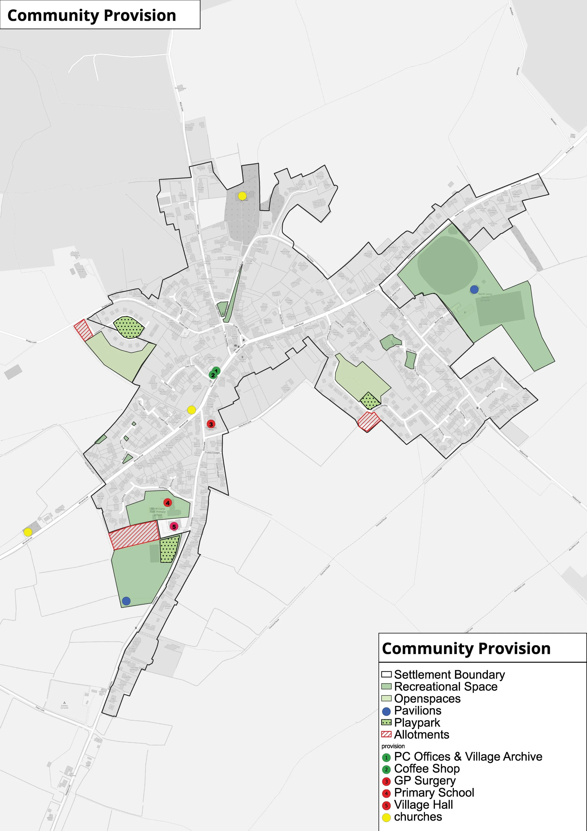
Community (Q11 to Q14)
The Parish benefits from two sports fields, three playparks, three pubs, three churches and medical centre and village store with Post Office that services an area that is wider than the Parish. The primary school had 156 pupils attending in the academic year 2022/23. The village hall and community coffee shop are well used facilities in the village.
Public Realm/Heritage (Q15)
A large proportion of the village is within a Conservation Area. There is one Grade I listed building in the village (the Church of St Peter and St Paul) one Grade II* listed building (Manor Farmhouse) and 39 Grade II listed buildings. In the wider Parish there are a further 18 Grade II listed buildings and one Grade II* (Manor House – Knapp).
Transport/Road Safety/Traffic (Q16 to Q18)
The A378 is the main A road through the southern part of the Parish, with bus service 54 and 55 that runs to Taunton and Yeovil every hour.
The main road which runs through the centre of the parish and the village is a B road, with a bus service that runs to Stoke St Gregory and Taunton six times a day, six days a week.
There is an extensive network of footpaths and bridleways through the wider parish, and roadside pavements in the housing estates and along Greenway from the village hall and school into the village centre, then along Church Road. Otherwise, none of the roads leading through the village have footpaths alongside them.
Open Space (Q19 and Q20)
There are more than nine areas of open space identified in the village (in addition to the sports field and play parks in the village). There are some planning policies that protect specific landscape areas currently – including Manor Field and some parts of the North Curry sandstone ridge.
Business and Employment (Q21 to Q25)
Around 46 businesses have been identified from Google maps in the Parish, 21 of which are associated with farms, camping and holiday lets. The village shop/Post office and three pubs are not large employers, and many of the businesses in the Parish employ less than 10 people. A large number of these smaller businesses are home-based businesses, and it is not known how many in the parish also work from home on a regular basis.
Tourism (Q26)
The holiday lets and camping in the Parish are the main focus for Tourism, plus the draw of the wildlife and walking opportunities on the levels. North Curry is on a main cycle (and several walking) routes, and the community coffee shop receives many day visitors.
Environment (Q27 and 30)
The wetland area of the levels is a RAMSAR site (internationally significant wetland habitats) and is also a Site of Special Scientific Interest (SSSI). This land is subject to periodic flooding which at times is significant enough to close the roads that cross them.
There are two other SSSIs in the Parish, the orchard field (between White St. and Broad Lane Fm.) and parts of the woodland near Rock Hill. Large parts of the parish are under Countryside Stewardship management schemes. The number of apple orchards reduced by the mid-1970s to the current more limited number, which reflect its agricultural heritage.